
Nurturing Tradition While Embracing Technological Advancements

In a world of advanced technology and automated systems, one practice remains a longstanding tradition for meteorologists: hand analysis in forecasting. Despite technological advancements, manually analyzing weather maps remains integral to forecaster’s toolkit, complementing models. Join the discussion as we uncover the historical origins of hand analysis. Explore its intricacies and see how it collaborates with weather model outputs. Additionally, gain valuable insights into performing hand analysis independently.
Unraveling the Threads of History: The Origins of Hand Analysis
Weather charts as we know them today began taking shape during the mid-19th century. Key figures like William Charles Redfield, Elias Loomis, and Sir Francis Galton pioneered the creation of the first weather maps. They used these maps to develop theories about storm systems. The telegraph, invented in 1837, revolutionized the process by enabling the rapid collection of weather data from distant locations. This allowed for real-time applications of hand analysis in forecasting.
From the 1840s to 1860s, Joseph Henry led the Smithsonian Institution in creating a network of observers across the U.S. It was a network made up of around 150 stations. By 1849, the Smithsonian began producing daily surface analyses using this network. Later, between 1870 and 1874, the U.S. Army Signal Corps inherited the network through an act of Congress. The Signal Corps then expanded it to the west coast.
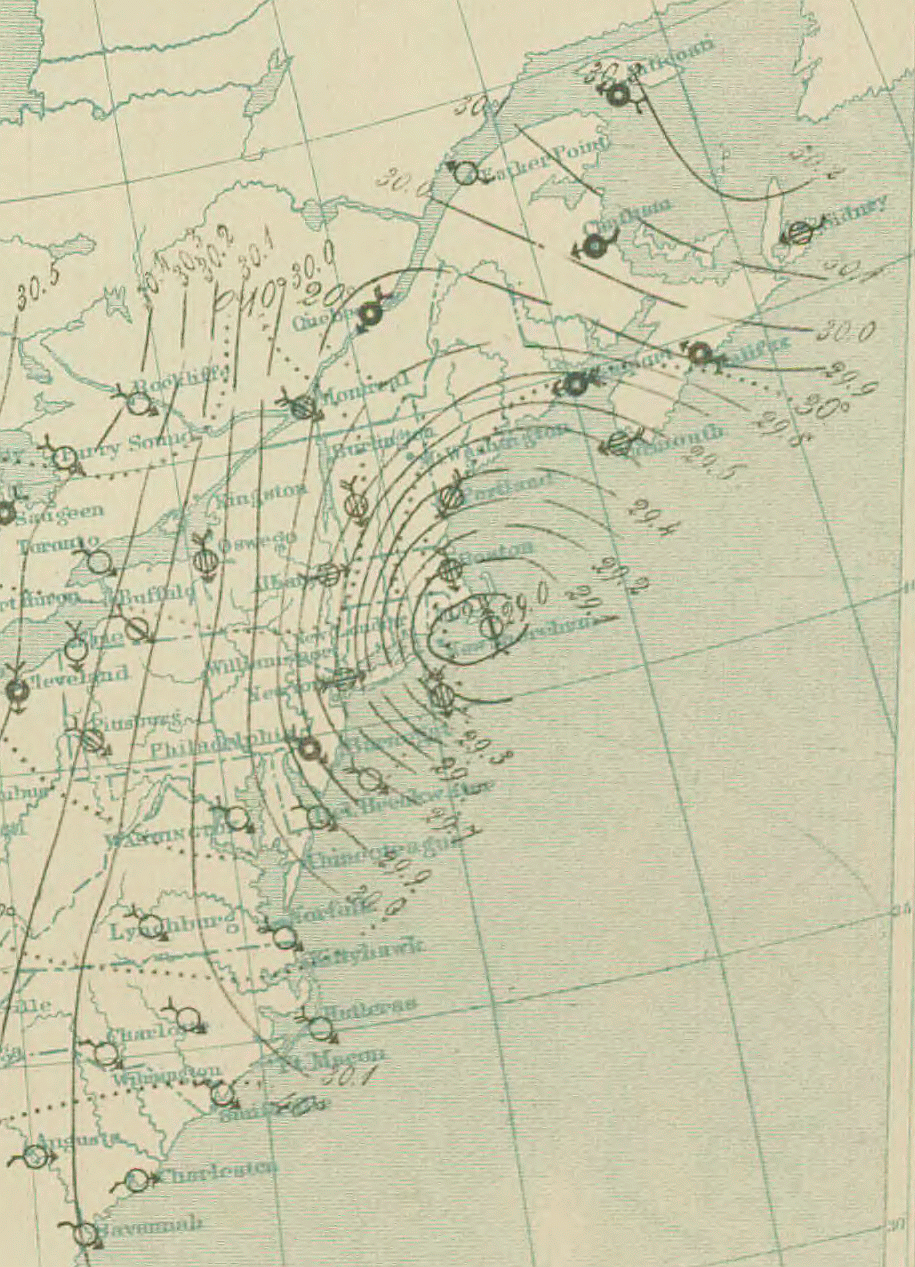
All stations would send their observations to a central office through telegraph communication three times a day. The central office would then plot this information on a map. Isobars, which are lines of equal pressure, would be drawn on the map. These isobars helped identify centers of high and low pressure, as well as squall lines.
Early analyses had inconsistent map data due to lacking time standardization for simultaneous measurements. The first attempts at time standardization took place in Great Britain around 1855. However, in the United States, standard time wasn’t established until 1883, when time zones were introduced for railroad use. It wasn’t until 1905 that the U.S. fully adopted time zones, Detroit being a significant player in establishing standard time.
Deciphering the Language of Maps: What is Hand Analysis?
Hand analysis in forecasting is a process that involves scrutinizing and interpreting weather maps to derive insights into the atmospheric conditions. Instead of relying on computer-generated forecasts, meteorologists engage in this manual examination to uncover nuances that automated systems might miss. It’s a dance between the art of intuition and the science of observation.
What Goes into Hand Analysis
Surface weather analysis entails creating specialized maps displaying weather elements in a certain location and time, utilizing ground-level station data. To make these maps, we mark relevant details like sea level pressure, temperature, and cloud cover on a geographical map. This helps us spot significant weather features like weather fronts that operate on a large scale.

When we analyze these maps, we use a station model for each observation point. The station model displays info like temperature, dewpoint, wind speed and direction, atmospheric pressure, pressure changes, and ongoing weather. The circle in the middle shows cloud cover; the more it’s filled, the cloudier it is.

For temperature and dewpoint, the model uses degrees Celsius outside the United States for upper levels. At ground level, degrees Fahrenheit are used only in the U.S. Wind direction is indicated by wind barbs. Each full flag equals 10 knots of wind while half a flag means 5 knots. If the wind speed reaches 50 knots, a filled triangle indicates intervals of 50 knots of wind.
In the U.S., rainfall, marked in the right-hand corner of the station model, uses inches. Globally, the standard unit for measuring rainfall is the millimeter. Once station models are on the map, we draw lines such as isobars (equal pressure), isallobars (equal pressure change), isotherms (equal temperature), and isotachs (equal wind speed).
Imagine standing beside a modern-day meteorologist, watching as they pore over a weather map. With a keen eye, they trace temperature contours, decode the intricacies of isobars, and visualize the interactions between pressure and wind patterns. Hand analysis transcends the digital realm, allowing forecasters to identify potential discrepancies. It can validate model outputs, and even foresee anomalies that could disrupt the expected weather patterns. Hand analysis also allows forecasters to see things they may otherwise miss.
Balancing Tradition and Technology: The Power of Hand Analysis
In an era dominated by advanced computer simulations and algorithms, you might wonder: why bother with hand analysis in forecasting? The answer lies in the nuanced dance between tradition and technology. While weather models excel at processing vast amounts of data and generating predictions, they aren’t infallible. Varied data input, complex atmospheric interactions, and unforeseen local conditions can lead to discrepancies between model outputs and actual conditions.
Imagine standing at a crossroads, trying to decide between GPS guidance and a local resident who knows the area intimately. Both have their strengths. GPS offers efficient navigation, but the local resident offers insights into shortcuts, hidden gems, and road closures unknown to computers. In a similar vein, hand analysis complements weather model outputs by adding human expertise. It contextualizes understanding and the ability to identify exceptions that models might overlook.
Guided by the Hand: Performing Your Own Weather Analysis
You might be wondering; how can you dive into the world of hand analysis yourself? While the intricacies can span entire careers, here’s a simplified guide to get you started:
Gather Data

Collect weather observations from various sources, such as temperature, pressure, humidity, and wind speed.
For aspiring weather analysts, the College of DuPage’s NexLab offers dependable weather observation resources. To get started, navigate to the “Weather Analysis Tools” menu and choose “Analysis Data.”
Once on the “Analysis Data” page, proceed to the “Analysis Products” menu located on the left-hand side. Here, select “Surface Maps.” From there, click on the option labeled “Printable Mapset.”
This is where you’ll find the raw data. Select the following maps: 250mb, 500mb, 700mb, 850mb, and 925mb. These maps provide insights into different atmospheric levels, enhancing your understanding of atmospheric complexities.
After selecting the Upper Air Maps, choose your specific region of interest. You can do this either by selecting from the provided list or by utilizing the map interface. Additionally, be sure to set the desired “Surface Time” on the right-hand side.
By utilizing this tool, you’ll gain access to a wealth of data that serves as the foundation of your analysis. This data reveals patterns and insights into atmospheric elements to formulate more accurate forecasts.
Identify Patterns
Observe the placement of isobars, analyze temperature gradients, and note wind direction and speed.
Embarking on the journey of hand analysis in forecasting requires a comprehensive understanding of deciphering intricate details within weather maps. Let’s delve into the specifics of this process:
- Isobars: Isobars are lines that connect areas sharing the same atmospheric pressure. These lines reveal pressure patterns across the map. When isobars are closely spaced, it suggests steep pressure gradients, indicative of strong winds. Conversely, widely spaced isobars signify gentler pressure gradients and calmer wind conditions.
- Isotherms: Isotherms are lines that connect regions with identical temperature readings. By observing isotherms, you can discern warm and cold air masses. Notably steep temperature gradients along isotherms often highlight frontal boundaries, where diverse air masses interact and influence weather conditions.
- Isodrosotherms: Isodrosotherms are lines connecting areas experiencing the same dew point temperature. These lines shed light on the amount of moisture in the atmosphere. Analyzing isodrosotherms in conjunction with isotherms provides insights into humidity levels and potential zones for cloud formation and precipitation.
- Isoheights: Isoheights, also known as contour lines, link regions at the same altitude within the atmosphere. These lines facilitate the visualization of the vertical composition of the atmosphere. Particularly valuable for upper-level maps, isoheights help determine the positioning of jet streams, troughs, and ridges.
- Isoplething: Isoplething is a technique employed to draw lines such as isobars and isotherms on a map. This method involves connecting data points with equivalent values and interpolating between them. Proficient isoplething results in a visual representation of the data, facilitating effortless identification of patterns and trends.
Mastering the skill of observing isobars, analyzing temperature gradients, and interpreting wind speed and direction is fundamental to your hand analysis toolkit. Proficiency in deciphering the language of weather maps empowers you. It enables you to unravel pressure systems, identify fronts, and comprehend atmospheric dynamics. This knowledge equips you to generate well-informed forecasts and actively contribute to the field of weather forecasting.
Download the Map Analysis Handbook

Analyze Features


Completed hand analysis maps for May 19, 2012; 250mb, 500mb, 700mb, 850mb, 925mb, Central Great Plains surface map. Hand drawn by Diana Milevska.
Look for high and low-pressure systems, fronts (boundaries between air masses), and anomalies that might deviate from expected patterns.
As you engage in the process of hand analysis in forecasting, adopting a comprehensive perspective is crucial. Let’s look further into specific aspects to consider:
- High and Low-Pressure Systems: Keep a keen eye out for indications of high and low-pressure systems. High-pressure areas typically correlate with fair weather and clear skies, while low-pressure regions often signify potential for clouds and precipitation. Identifying these systems lays the groundwork for understanding broader atmospheric dynamics.
- Weather Fronts – Meeting Points of Air Masses: An essential component of hand analysis involves detecting weather fronts, which are the intersections where distinct air masses converge. These fronts often herald changes in weather conditions. By pinpointing warm fronts, cold fronts, and occluded fronts, you can gain insights into shifts in temperature, humidity, and wind patterns.
- Anomalies and Deviations: In the process of scrutinizing weather maps, it’s imperative to stay vigilant for anomalies or deviations from anticipated patterns. These outliers can offer critical insights into the complexities of the atmosphere. Observing unexpected variations, such as unusual wind directions or abrupt temperature changes, equips you to refine your analysis and deliver more accurate forecasts.
By adopting a holistic approach to hand analysis in forecasting and observing key elements, you can decipher intricate atmospheric dynamics. This methodical approach empowers you to unravel the nuanced interactions that contribute to weather patterns and enhance your forecasting capabilities.
Local Factors

Consider local topography, large bodies of water, and other geographical features that can influence weather conditions.
When engaging in hand analysis for forecasting, adopting a holistic perspective that incorporates geographical factors is essential. Let’s tap into specific elements that warrant your attention:
- Local Topography: Acknowledge the influence of local topography on weather patterns. Mountains, valleys, and elevation changes can significantly impact wind flow, precipitation distribution, and temperature variations. Understanding how terrain interacts with atmospheric conditions enhances the accuracy of your analysis.
- Large Bodies of Water: The presence of large bodies of water, such as oceans and lakes, plays a pivotal role in shaping weather dynamics. Bodies of water can modulate temperature, increase humidity, and contribute to cloud formation. Recognizing the effects of nearby water sources allows you to anticipate potential weather changes.
- Other Geographical Features: A diverse range of geographical attributes, such as urban areas, forests, and deserts, can significantly impact weather phenomena. Deserts can form drylines—sharp boundaries between moist and dry air—impacting weather dynamics distinctly. Analyzing these features is pivotal in gaining a thorough grasp of the intricate interplay between local geography and atmospheric conditions.
By integrating geographical considerations into your hand analysis process, you gain a broader perspective on interactions that shape weather patterns. This holistic approach empowers you to generate forecasts that account for the intricacies of the environment. It results in more accurate predictions and informed decision-making.
Compare with Models

Once you’ve performed your analysis, compare your observations with weather model outputs to identify areas of agreement or disagreement.
After completing your thorough hand analysis in forecasting, a crucial step involves validating your observations. Let’s further explore this process:
- Compare with Weather Model Outputs: Once you’ve diligently analyzed the weather maps by hand, it’s wise to compare your observations with the outputs generated by weather models. These include the High-Resolution Rapid Refresh (HRRR), Rapid Refresh (RAP), North American Mesoscale (NAM), and NAMNST (NAMNest). Each model employs sophisticated algorithms and extensive data inputs to anticipate atmospheric behavior. By juxtaposing your observations with the forecasts generated by these models, you can discern areas of alignment or disparity.
- Identify Areas of Agreement or Disagreement: During the comparison process, focus on identifying points where your hand analysis concurs with the model outputs. This alignment reinforces the accuracy of your manual assessment and enhances your confidence in the results. Conversely, areas of disparity between your analysis and model predictions can signal unique local conditions or anomalies that merit further investigation.
- Holistic Validation: Combining the insights derived from both hand analysis and weather model outputs offers a holistic approach to weather forecasting. This synergistic validation process refines prediction accuracy. It also deepens comprehension of intricate atmospheric variable interactions.
By subjecting your hand analysis to this rigorous comparison and validation, you elevate the credibility of your findings. This meticulous approach ensures forecasts are rooted in manual scrutiny. It benefits from technology-driven model advancements as well.
Refine Your Skills
The journey towards expertise is paved with dedicated practice. Consistent hand analysis in forecasting hones your skill in pattern recognition and understanding atmospheric dynamics intricately. This iterative process sharpens your skills. It positions you as an adept interpreter of weather map intricacies.
Continuing the Tradition: The Hand Analysis Legacy
In a rapidly evolving world, the practice of hand analysis in forecasting stands as a testament to the enduring value of tradition. Technology advances accuracy, yet human observation, intuition, and interpretation remain irreplaceable in enhancing predictive capabilities.
Envision meteorological knowledge passed down through generations. Each adds unique insights to the tapestry of weather forecasting. Hand analysis bridges the past and future, linking pioneers’ wisdom with the potential of cutting-edge technology.
While navigating weather forecasts, remember behind algorithms and simulations are minds versed in the art and science of hand analysis. These meteorologists uphold a tradition merging pen-and-paper elegance with computational power. When you view a weather map, pause to appreciate the balance between tradition and technology. Acknowledge the forecasters who dedicate themselves to blending the two in pursuit of accurate predictions.